Texas lake trips can become complicated when the water retreats from the facilities you planned to use. A boat ramp may remain open while its courtesy dock closes. A campground may welcome visitors even though canoe rentals have stopped.
The useful question is whether your group can complete its planned activity using the access available on your travel dates. That requires a closer look than a lake photograph, a campsite reservation or a general statement that the park is open.
Identify the Facility Your Trip Depends On
Before researching conditions, decide what would make the visit worthwhile.
A family planning to rent canoes needs an operating rental service and a usable launch. Someone towing a fishing boat needs a suitable ramp, trailer parking and a workable boarding arrangement. A visitor who relies on a level route to a fishing pier needs information about that particular facility.
Write down the exact park entrance, ramp, dock or rental location you intend to use. This gives you a specific place to investigate.
If your plans depend on several facilities, check each one. Avoid treating a park’s general list of amenities as confirmation that everything listed will be available during your visit.
Use Water Levels as Context
Reservoir data can help you understand whether water levels are rising or falling, but it cannot settle every access question.
The Texas Water Development Board calculates “percent full” by comparing conservation storage with conservation capacity. Its published reservoir figures include daily averages, and the agency notes that these may be unsuitable when near-real-time information is needed.
For trip planning, that means a storage percentage should not be treated as a launch guarantee. It does not describe the depth at the end of your chosen ramp or the condition of the path to a dock.
Check the measurement date and recent trend, then obtain facility-specific information from the operator. Do not assume that rainfall near your home has restored access at a lake elsewhere in Texas.
Confirm the Exact Boat Ramp
Ask about the named ramp you intend to use. Different ramps around the same reservoir can have different operating conditions.
A TPWD notice dated September 11, 2025, for Cooper State Park illustrates this distinction: it identified the Honey Creek ramp as closed because of low water while naming other ramps that remained open. That notice is an example of why individual ramp status matters, rather than a forecast for your travel date.
When speaking with staff, describe your boat and trailer. Useful questions include:
- Is the ramp open for launching and retrieving this type of boat?
- Are there warnings about the end of the paved surface?
- Is the approach clear, and is trailer parking available?
- Are any temporary restrictions affecting its use?
Ramp edges deserve particular attention. A TPWD fisheries report documented a ramp kept closed because a sharp drop-off could trap or damage trailers. Do not back beyond an unknown edge or bypass a closure barrier.
Check Courtesy Docks Separately
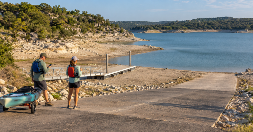
A courtesy dock provides a place to board, unload passengers or temporarily secure a boat while someone handles the trailer. Its availability can determine whether a launch works for your group.
At Lake Casa Blanca International State Park, a notice dated August 28, 2025, described the courtesy dock as closed because of low water while the concrete ramps remained open. The two facilities therefore had different statuses.
Ask how passengers are expected to board if the usual dock is unavailable. Consider children, anyone with limited mobility and the experience of the person handling the boat.
If your group cannot board and return safely under the available arrangement, choose another access point. An open ramp does not resolve that practical limitation.
Confirm Rentals and the Carry to the Water
For paddlers, equipment availability and shoreline access are separate checks.
Caddo Lake State Park’s October 21, 2026, alert announced that both canoe rentals and the boat ramp were closed because of extremely low water. This shows why a park’s normal rental offering should be checked against its latest alerts.
If bringing your own kayak or canoe, ask whether there is an authorized launch and how far you must carry the craft from parking. Request details about slopes, steps, mud and other obstacles along the route.
Think about the return carry as well. A route that seems manageable with an empty kayak may be difficult after several hours outside, especially with wet equipment.
For rentals, confirm where you collect the boat, whether assistance is available and the required return time. Wear a properly fitted life jacket when paddling.
Assess Shore Access and Hazards Beyond the Launch
Lower water can expose ground between an established path and the lake. That exposed area should not automatically become your walking route, swimming entrance or vehicle access.
Ask staff where visitors may approach the water and whether there is a firm, usable path. Keep vehicles on authorized routes and respect barriers around closed facilities.
Conditions beyond the shoreline also matter. Lake Livingston State Park’s August 26, 2026, low-water alert warned visitors about exposed trees and stumps near the boat ramp.
For bank fishing or swimming, investigate the specific area you plan to use. Ask about current closures and local hazards. Avoid jumping or diving into water where depth and underwater obstacles are uncertain, even if you have visited the same spot before.
Choose an Alternative That Fits the Whole Route
Save an alternative access point before leaving, but evaluate more than its distance from the original ramp.
Check the driving route, entrance hours, fees, parking and any reservation requirements. A location that looks nearby across the water may require a substantial drive around the reservoir.
Changing launch points also changes the outing on the water. Reconsider the distance to your destination, exposure to wind and the route back. A replacement launch is useful only if the resulting trip suits your equipment and experience.
For example, moving to the opposite shore might solve a ramp problem while creating a longer paddle than your group planned. Shorten or change the activity if the revised route no longer fits.
Download directions and share the new meeting point with everyone travelling separately.
Review Booking Terms and Prepare a Land-Based Option
Before paying for accommodation or equipment, decide which access problem would cause you to change the trip.
Review cancellation and modification terms for each booking. If an essential facility closes, contact the reservation provider promptly to ask what options apply. Do not assume that a ramp closure automatically changes the terms of a campsite or lodging reservation.
Our guide to Texas state park reservations, fees and rules can help with the broader arrangements around your visit.
Choose a specific alternative activity, such as an open walking trail, birdwatching area or nearby museum. Check its hours and suitability for the forecast so it is a usable option.
Review official alerts again shortly before departure. If they leave an important question unanswered, call the facility before committing to the drive.
Note: The dated notices above illustrate access problems and may change. Use the Texas Parks and Wildlife Lake Finder to locate lake information, then confirm current conditions with the operator of your chosen access point.